


An icy mix of sleet and freezing rain over the interior will give way to rain followed by a brutal arctic blast to start the week. Snow squalls will be a threat through Tuesday.
TODAY
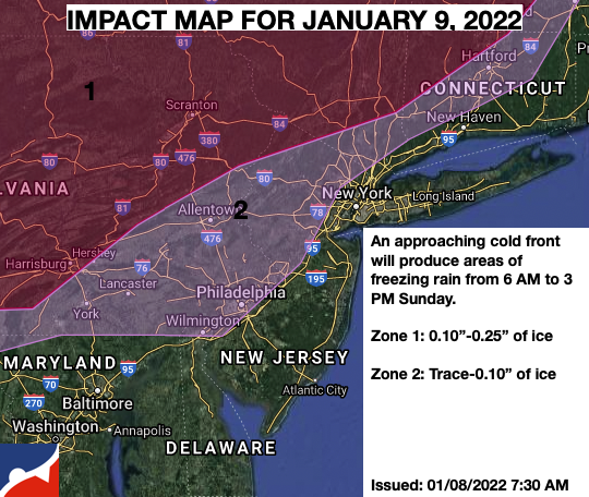
A cold front will approach the region with periods of freezing rain giving way to rain through the morning into the early afternoon hours. Showers will linger into the evening. Winds will veer from the southwest to the northwest at 5 to 15 mph. Temperatures will rise into the mid to upper 30s over the interior and upper 30s to lower 40s along the coast for highs.
TONIGHT
Skies will clear with a few flurries a threat after midnight. Winds will veer to the northwest at 5 to 15 mph. Temperatures will fall into the lower to mid-10s over the interior and upper 10s to lower 20s along the coast for lows.
TOMORROW
Scattered clouds with flurries and a few lake-effect snow showers, especially in the Poconos and Catskills, can be expected. Winds will be from the northwest at 5 to 15 mph. Temperatures will range from the lower to mid-10s over the interior and upper 10s to lower 20s along the coast for lows and lower to mid-20s over the interior and mid-20s to lower 30s along the coast for highs.
TUESDAY
A weak trough will pass through with scattered clouds along with flurries and an isolated snow squall. Snow squalls will be capable of reducing visibility below 2 miles and produce brief heavy snow. Winds will be from the northwest at 5 to 15 mph. Temperatures will range from the single digits to mid-10s for lows and lower to mid-10s over the interior and mid-10s to lower 20s along the coast for highs.
WEDNESDAY THROUGH THURSDAY
High pressure will produce clear but cold weather conditions. Temperatures on Wednesday will range from the single digits to the mid-10s for lows and lower to mid-30s over the interior and mid to upper 30s along the coast for highs. Temperatures on Thursday will range from the upper 10s to mid-20s for lows and mid to upper 30s over the interior and lower to mid-40s along the coast for highs.
FRIDAY
An area of low pressure off the coast will produce isolated to widely scattered snow showers. Temperatures will range from the mid to upper 10s over the interior and 20s along the coast for lows and upper 20s to lower 30s over the interior and mid-30s to lower 40s along the coast for highs.
SATURDAY
An approaching area of low pressure will produce scattered rain and snow showers. Temperatures will range from the mid to upper 10s over the interior and upper 10s to the lower 20s along the coast for lows and lower to mid-30s over the interior and upper 30s to lower 40s along the coast for highs.
SUNDAY
A strong area of low pressure will produce periods of snow over the interior and a wintry mix of snow, sleet, and rain along the coast. Temperatures will range from the upper 10s to the lowers 20s over the interior and mid-20s to lower 30s along the coast for lows and mid to upper 20s over the interior and lower to mid-30s along the coast for highs.


