

UPDATED 05/21/26 9:39 AM
A new damp weather pattern has now been established with waves of showers today and more rainfall through the Memorial Day Weekend.
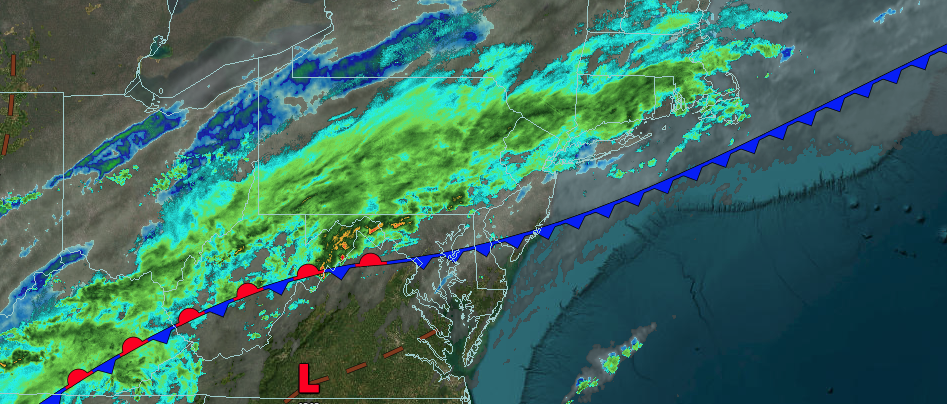
TODAY
A cold front will produce overcast skies and waves of showers. Winds will be from the northeast at 5 to 15 mph. High temperatures will range from the lower to mid-60s.
TONIGHT
High pressure will build southward with scattered clouds and isolated showers. Winds will be from the east at 5 to 15 mph. Low temperatures will range from the upper 40s to lower 50s over the interior and lower to mid-50s along the coast.
TOMORROW
A stationary front will produce scattered to broken cloud cover and isolated showers. Winds will be from the east at 5 to 15 mph. High temperatures will range from the mid-60s.
TOMORROW NIGHT
A stationary front will produce overcast skies and widespread showers. Winds will be from the east at 5 to 15 mph. Low temperatures will range from the mid to upper 40s over the interior and lower 50s along the coast.
SATURDAY
A warm front will produce periods of rain, heavy at times. Winds will be from the east at 5 to 15 mph. High temperatures will range from the upper 40s to lower 50s over the interior and mid to upper 50s along the coast.
SUNDAY
An area of low pressure will produce overcast skies and scattered showers. Winds will be from the northeast at 5 to 15 mph. Low temperatures will range from the mid to upper 40s over the interior and lower to mid-50s along the coast. High temperatures will range from the upper 50s to lower 60s over the interior and Long Island and mid-60s on the I-95 corridor.
MEMORIAL DAY MONDAY
A stationary front will produce variable clouds and isolated showers. Low temperatures will range from the lower to mid-50s over the interior and mid to upper 50s along the coast. High temperatures will range from the lower to mid-70s.
TUESDAY
A trough will produce scattered clouds and isolated showers. Low temperatures will range from the upper 50s to the lower 60s. High temperatures will range from the mid-70s.
WEDNESDAY
A trough will produce scattered clouds and isolated showers. Low temperatures will range from the mid to upper 50s over the interior and upper 50s to lower 60s along the coast. High temperatures will range from the mid-70s over the interior and Long Island, and upper 70s to lower 80s elsewhere.
THURSDAY
A trough will produce scattered clouds and isolated showers. Low temperatures will range from the lower to mid-50s over the interior, upper 50s to lower 60s in the suburbs, and lower to mid-60s in urban areas. High temperatures will range from the mid to upper 70s.

