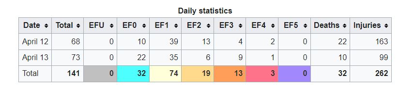
Since Easter Sunday usually falls between late March and early April (as the tornado season revs up) we can assume that throughout weather history that some notable tornado events have occurred. That certainly was the case just six years ago when the COVID crisis was ascending into full gear that during Easter Sunday and Monday (April 12–13), a wide scale and destructive tornado outbreak plowed across the Southern and Eastern U.S, The total number of tornadoes confirmed from the outbreak is 141 in slightly less than thirty seven and a half hours !
Meteorological Conditions
The table was set early for this event. March of 2020 was very warm across the southern U.S. as a ridge of high pressure aloft was a dominant feature. The ridge extended into the Gulf and sea surface temperatures were 3.6 degrees F above the 40-year average so any air mass moving northward wound be abnormally warm and moist.
Well ahead of this event, Meteorologists were tracking an potent upper-level trough moving from the western U.S. toward Texas and eventually across the South.. The Storm Prediction Center (SPC) outlined 15% probabilities for severe weather within 25 miles of a point from central Texas eastward into the Florida Panhandle and eastern Georgia valid for April 11–12. For that time, this was much earlier than usual for these alerts.
Low pressure developed in the Texas Panhandle area while a second low was forming near the Gulf. A warm and moist air mass started to rush northward.
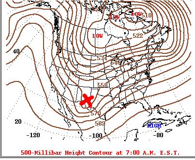
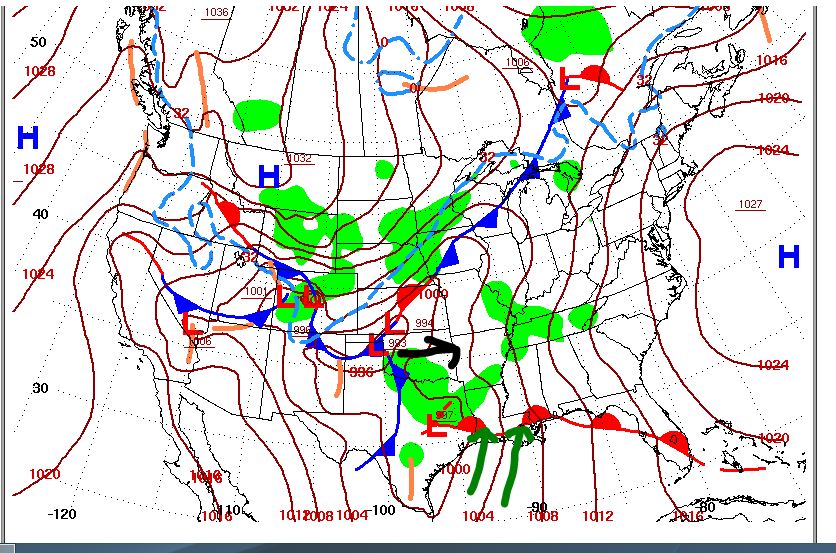
The map on the left shows conditions at the upper-levels (500 mb) on April 20,2000. It shows a vigorous upper-level trough (x) moving toward Texas which was a trigger mechanism for sever storms and tornadoes. The surface map for the same time period on the right shows developing low pressure in the Texas area and a surging northward from the Gulf. Map Credits-NOAA.
By the pre-dawn hours of April 12, mid-level cooling associated with the trough overspread Hill Country and much of central Texas. in addition, an intense line of severe thunderstorms developed along a dry line while vigorous thunderstorm development formed farther east. The initial storms produced scattered weak tornadoes in Texas during the early stages of the outbreak.
April 12th – Easter Sunday
The storm system progressed across northern Louisiana through the late morning and early afternoon hours, and embedded circulations within the line began producing strong tornadoes. The first strong tornado as well as the first one to cause casualties was in De Soto Parish where an EF2 tornado destroyed manufactured homes and damaged trees and homes, injuring two people. The first intense and notable tornado was an EF3 tornado that triggered a Tornado Emergency as it moved through downtown Monroe, and damaging or destroying numerous homes but there were no deaths or injuries reported. Damage at Monroe was estimated to be around 240 million dollars!
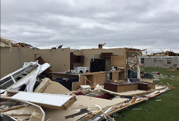
This photo shows extensive damage inflicted by an EF-3 tornado at Monroe, Louisiana, on April 12, 2000. Photo Credit-NWS-Public Domain.
Another EF3 tornado near Sterlington, caused extensive tree damage. In advance of a squall line, the warm front aided in the formation of a very moist, highly unstable, and highly wind sheared environment across northeastern Louisiana and much of Mississippi. The SPC issued a particularly dangerous situation tornado watch into late evening !
As the low pressure system progressed across northwestern Mississippi, it caused surface winds to turn to the east-southeast, which produced more wind shear and enhancing the potential for tornadoes. As a cluster of storms across central Mississippi progressed toward the northeast, it began to reintensify and develop embedded supercells!
Farther south, two distinct supercells developed where long-tracked, significant tornadoes were favored, both exhibiting extremely strong rotation and distinct debris signatures on radar. SPC mentioned that “this is an exceptionally rare event” and estimated tornadic winds of 170–205 mph on the first supercell, consistent with a tornado of at least an EF4 intensity.
After conducting damage surveys, meteorologists identified two violent tornadoes with the first supercell, one that killed four people and injured three others near Sartinville to southwest of Bassville and a second that killed eight people and injured 95 others from south of Bassfield to Pachula , both of EF4 intensity.
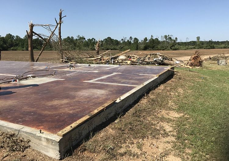
This photo shows a building ripped off its foundation and destroyed by an EF-4 tornado at Bassfield, Missouri on April 12,2000. Photo Credit- NWS Public Domain.
A long-tracked EF3 tornado was identified with the second supercell that tracked behind the first one, producing significant damage near Oak Vale and Carson, injuring two people. The first supercell also produced two other tornadoes after the second EF4 tornado dissipated, including an EF2 tornado that passed near Stonewall and Enterprise that destroyed a mobile home and heavily damaged a home and a church, and snapped numerous trees. The second supercell also produced a tornado, which was rated EF1, as it passed Enterprise. Both supercells then weakened and merged with the squall line.
During the evening, the main tornado threat shifted eastward into Alabama, as the initial cluster of severe storms with numerous embedded semi-discrete supercells and comma-head circulation moved across north-central Alabama, contributing to multiple strong tornadoes. This included a damaging rain wrapped EF2 tornado that struck a residential area at the southwestern outskirts of Boaz injuring three people. Later, a high-end EF1 tornado caused major damage and three injuries in Carbon Hill.
The storms continued into northwestern Georgia. This thunderstorm complex produced 43 tornadoes alone, including nine rated EF2 and two rated EF3. A high-end EF2 tornado spawned by an isolated supercell thunderstorm ahead of the main complex carved a path northwest of Chatsworth, Georgia and through the small town of Sumac, killing eight people and injuring 24 others.
Dew points began to rise significantly across northern Georgia and southeastern Tennessee behind the surging warm front boosting instability values in an extremely strong wind shear environment An EF3 tornado embedded within the main line of storms killed two people and injured 18 others in the eastern suburbs and neighborhoods of Chattanooga, Tennessee The same storm also produced an EF2 tornado that damaged or destroyed numerous homes and mobile homes in eastern Cleveland, Tennessee, injuring six people.
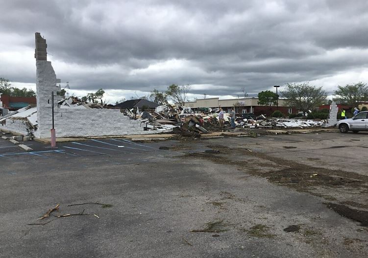
This photo shows extensive damage to the Bella Vista subdivision at Chattanooga, Tennessee late on April 20, 2000. Photo Credit-NWS-Public Domain.
April 13th – Easter Monday
During the early-morning hours of April 13, the squall line shifted eastward into eastern Georgia and the Carolinas, with numerous well-organized embedded supercells forming within the line, producing numerous tornadoes across the region in an event known as the Central Savannah River outbreak.
Northwest of Atlanta, an EF1 tornado passed through Cartersville, Georgia, killing one person when a tree fell on a house while causing two additional injuries elsewhere.
An EF3 tornado that damaged or destroyed multiple homes was confirmed south of Thomaston to northwest of Rebone with one home being pushed off its foundation and into the middle of a road. The same circulation produced another EF3 tornado near Forsyth (north of Macon) injuring one person and damaging or destroying numerous structures and vehicles.
Another tornado from south-southeast of Westminister in South Carolina killed one person and caused major damage in Seneca. One more EF3 tornado tracked from east-northeast of Elko to west-southwest of St. Matthews in South Carolina and two more people died.
The most powerful tornado on April 13 was an EF-4 that killed five people near the South Carolina towns of Estill and Nixville This tornado was part of a complex that produced 12 tornadoes, including an EF1 tornado that killed one person in Walterboro.
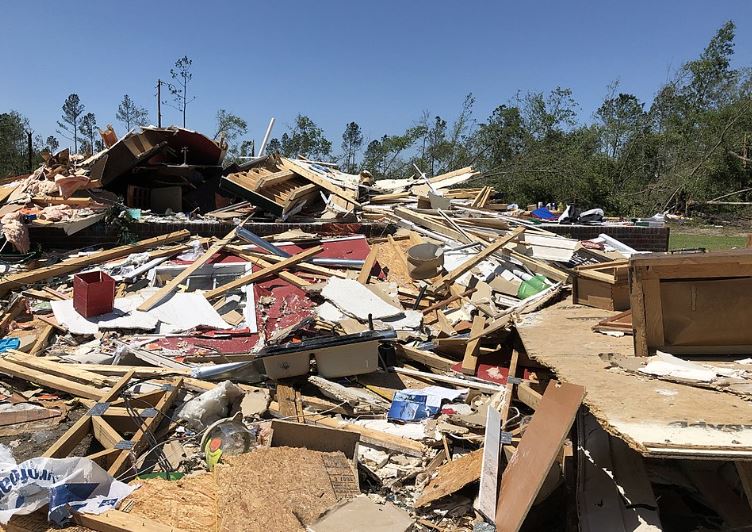
A photo showing the destruction of a 2-story house in Nixville, South Carolina, from an EF-4 tornado on April 13, 2000. Photo Credit – NWS- Pubic Domain.
Eight more EF3 tornadoes were confirmed across Georgia and South Carolina. During the late morning hours of April 13, the line of intense thunderstorms continued eastward and intensified. Later, more severe storms formed over the Appalachians and moved into major Northeast cities, where a slight risk had been issued from the SPC. The result was a large area of damaging winds and two weak tornadoes throughout this area for the rest of day until the outbreak wound down.
Tornado Outbreak Statistics
The estimated damage from this event was just under 4 billion dollars ! The death toll was adjusted up to 35.
The COVID pandemic took a heavy toll on the 2020 Easter Tornado Outbreak’s recovery efforts and in some cases it prevented timely disaster relief. It took years to return to some form of normality in many locations.
Statistics from the NWS below