


UPDATED 02/21/26 5:01 PM
A major winter storm will impact the region tomorrow through Monday morning with a variety of impacts. Here are the details on this storm.
SUNDAY: 4 AM to 6 PM
As the low-pressure system develops to our south, scattered rain and snow showers will develop around the region. With temperatures in the 30s and 40s, snow accumulation will not be expected in this time period. Most of the region can expect temperatures to begin to fall towards freezing in the evening with minor snow accumulation on cold surfaces.
SUNDAY 6 PM to 12 AM
As the new coastal low-pressure system intensifies, an inverted trough will develop from the Delaware Coast to southeastern Pennsylvania, producing moderate snowfall in zone 1 and light snowfall in zone 2. With temperatures falling below freezing, snow accumulation will begin to increase on all surfaces. Meanwhile, light snowfall will begin to accumulate in zones 3, 4, and 5.
MONDAY 12 AM to 12 PM
The coastal low-pressure system takes over and rapidly intensifies. As temperatures fall between the upper 20s and lower 30s throughout the region, all locations can expect snow accumulation. The snowfall will pick up intensity in zones 4 and 5, while zone 1 sees a decrease in intensity. Zone 3 will be caught between the two heavy snowfall zones, which will keep the snowfall light to moderate. Meanwhile, the intensifying low-pressure system will support winds of 15 to 30 mph on the coast with gusts between 30 and 50 mph. Poor visibility and power outages will be a threat in zones 4 and 5. Coastal flooding will be a threat in zone 5.
MONDAY 12 PM to 6 PM
The low-pressure system departs with lingering snow showers. Temperatures will be in the lower to mid-30s with limited, if any, additional snowfall accumulation.
This snowfall will be a heavy, wet type of snow. Use caution with snow removal!
Additional Impacts:
There is a high threat of coastal flooding along the New Jersey coast and Long Island with the tides one to two feet above ground level from tomorrow evening through Monday morning.
The combination of sustained winds of 15 to 30 mph and gusts up to 60 mph will produce visibility below a mile, power outages, and minor to moderate wind damage.
REASONING
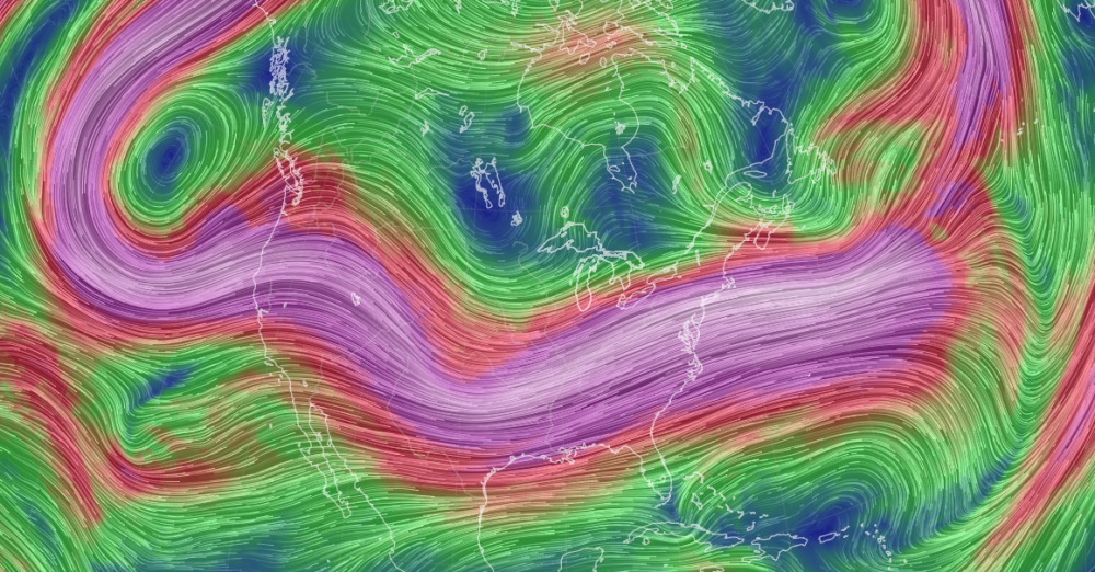 The support for the winter storm, as discussed over the past 48 hours, is that the ridge axis over the Rockies has set up at the perfect location, with perfect amplification and timing to support the amplification of the trough over the Plains and eventually the East Coast. This process will support the phasing of shortwaves over the Tennessee River Valley tonight and develop an intensifying 500 MB low-pressure system that will track from the Tennessee River Valley to the coastal waters of New Jersey tomorrow through Monday morning. If the ridge were to the east by just 300 miles, the whole storm threat would not be possible, given the very progressive nature of the weather pattern in the Atlantic.
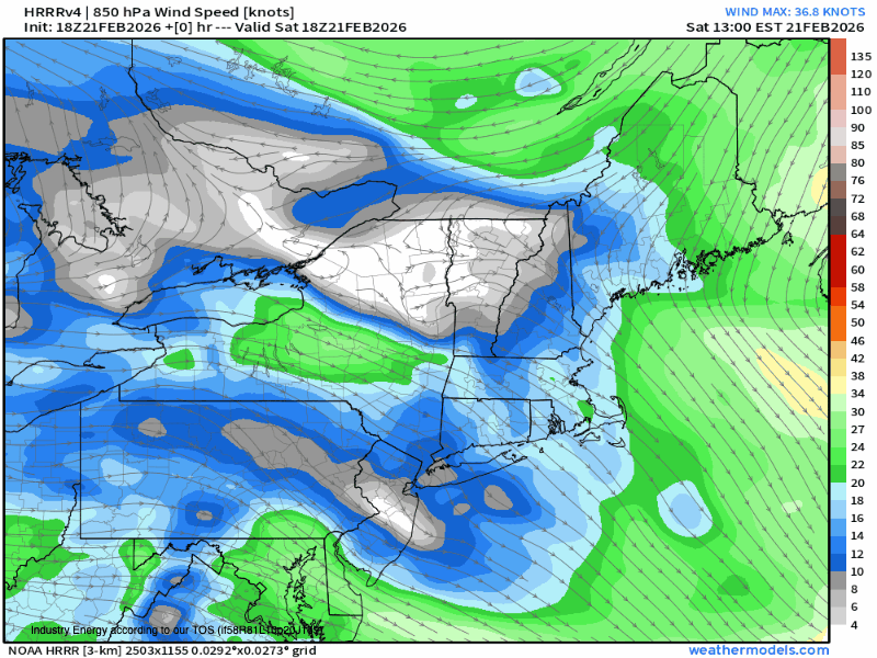 The blizzard conditions are possible tomorrow night through Monday morning due to the rapidly intensifying 850 MB low-pressure system that will lift through the coastal waters. As the strong produces intense areas of lifting and sinking air, which will be touched on in the discussion below, the winds at 850 MB at nearly 85 knots will mix down to the surface, supporting sustained winds in the 15 to 30 mph range and gusts up to 60 mph, especially along the coast from New Jersey through Long Island and Connecticut.
BOUNDARY LAYER TEMPERATURES AND SNOW RATIOS
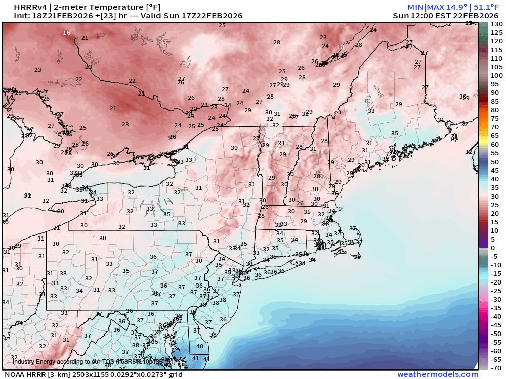 The boundary layer temperatures at the start of this storm will be above freezing, supporting a rain/snow mix, while road temperatures will be above freezing as well, which means that the first few hours of this storm will feature a mix of rain and snow or a very wet snow that is very difficult to accumulate. This factor is not well handled by the model snow maps. Thus, adjustments were needed.
There is no doubt that by 6 PM tomorrow, all levels of the atmosphere will support snowfall. This polar air mass, enhanced by the strong lifting of the 500 MB low-pressure development, will support a type of snowfall ratio of 8:1 to 12:1, depending on whether a location is in a snow band or not. The intense lifting will cool the column of the atmosphere, and the sinking will support warming of the atmosphere. This process will produce snowfall rates of 1″ to 3″ per hour from 10 PM tomorrow night through 6 AM Monday morning, supporting the expected snow accumulation. If snowfall rates push to 4″ per hour as some mesoscale models suggest, there is potential for a few locations to go over two feet. However, 4″ per hour snowfall rates are very difficult to pull off.
STRONG LIFT, BUT WHERE IS THE SINKING AIR


The primary bust potential for this storm is where the intense snow band sets up.
Many have asked why, in zone 3, I am going so low when many outlets, including the NWS, are going significantly higher. The answer comes down to rising and sinking motion.
If there are going to be snowfall rates of 1″ to 4″ per hour on the coast, then there must be an equal and opposite reaction. That reaction is experienced in many winter storms, and this one will be no different.
With an inverted trough over southeastern Pennsylvania tomorrow evening, enhancing snowfall totals in east-central Pennsylvania and lifting intensifying along the coast, there must be an area of sinking air around the Delaware River Valley and northern New Jersey. However, some guidance pushes this banding further west, towards the Hudson Highlands and the Delaware Water Gap, which would expand the potential for intense snowfall rates. Still, the process remains, and that means sinking air will also shift to the west. My point is that some locations are going to have periods of very light snow, while locations to the east will experience blizzard conditions. The question is not if, but simply where. Thus the bust potential in some of these locations away from the coast.
This is going to be a very complicated storm, and there is no doubt that this storm will produce intense snowfall. Regardless of whether you have 6″, 12″, or 24″, this snow will be of the heavy, wet variety and very difficult to move. Please use caution when shovelling.
Also, this storm will make travel conditions very poor tomorrow night through Monday morning. If possible, please do not travel and work from home. Visibility will be near zero, and wind gusts will create dangerous conditions. Let the people who bravely go out to clear up the streets for this storm do their job. Perhaps hand out some coffee for them while you are at it.


