

Here in 2025, the peak of the Atlantic hurricane season has been about as quiet as it could be. The situation was vastly different back in the 1950s when the U.S. East Coast was blasted by a number of major hurricanes. One of these was Hurricane Hazel in 1954 !
Hurricane Hazel was one of the costliest and deadliest hurricanes to strike the U.S. in the 20th century and it remains as the farthest north land falling Category 4 hurricane on record in the U.S.
Hazel’s Journey And Impacts
As mentioned, Hurricane Hazel was the farthest north Category 4 hurricane to make landfall in the U.S. Hazel was first recorded in early October, as a tropical storm east of the Lesser Antilles. It quickly became a hurricane and continued to move westward into the Caribbean Sea through October 8th.
After that, it made an abrupt turn to the north, By October 9th, Hazel had intensified to Category 4 hurricane with maximum sustained winds of 135 mph. Between October 9th and 12th Hurricane Hazel moved northward and then north-northeastward crossing western Haiti on October 11th. Passage over Haiti weakened Hazel to a 100 mph Category 2 hurricane. The effects of heavy rain and destructive winds left a very high death toll in Haiti. Some reports indicated that over 1,000 people may have perished.
After passing over Haiti, Hazel quickly reintensified to a Category 4 hurricane once again. On October 13th, Hazel passed over the southern Bahamas before veering to the northwest. On October 14th a hurricane hunter aircraft found winds up to 150 mph. Hazel’s forward speed increased rapidly to 30 mph as it made its way toward the U.S. Coast.
Hurricane Hazel made landfall on the morning of October 15th as a Category 4 hurricane with maximum sustained winds of 130 mph at Long Beach/Oak Island, North Carolina, near the South Carolina border. A combination of wind gusts, estimated to be 140-150 mph and a 17 to 18-foot storm surge, practically obliterated beach areas around and north of its landfall.
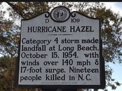
A photo of a government marker at Long Beach Pier, North Carolina (Oak Island) where Hurricane Hazel made landfall in 1954. Photo Credit -North Carolina Office Of Archives and History.
A 98 mph wind gust was recorded measured in Wilmington, North Carolina, while winds were estimated at 125 mph at Wrightsville Beach and 140 mph at Oak Island. The storm surge coincided with the time of the high tide and Hazel nearly wiped out Garden City, Nineteen people were killed in North Carolina, with several hundred more injured; 15,000 homes were destroyed and another 39,000 were damaged. Damages in the Carolinas amounted to $163 million (nearly 2 billion n 2025 dollars). Beach property incurred $61 million of damage alone (735 million 2025 dollars).

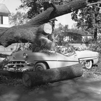
A photo showing extensive damage from Hurricane Hazel in coastal North Carolina on October 15, 1954. Public Domain.
During the day on October 15th, Hazel raced northward and made it all the way to Pennsylvania by evening as it began to lose its tropical characteristics. Wind gusts from 90 to over 100 mph, remained with it. Fayetteville, North Carolina, recorded a wind gust of 110 mph. and the Raleigh-Durham Airport. gusted to 90 mph. Myrtle Beach, South Carolina had a wind gust to 106 mph.
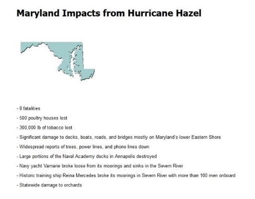
Wind gusts near 100 mph were reported at numerous locations in Virginia, Maryland, Pennsylvania,
Delaware, New Jersey, and New York as Hazel raced northward. Philadelphia, Pennsylvania, and Binghamton, NY reported wind gusts to 94 mph and in New York City, a peak gust of 113 mph was recorded at the Battery at the south end of Manhattan. That is the highest wind gust on record for New York City.
Needless to say, winds like that produced all kinds of damage. Trees and power lines were down everywhere. The city of Philadelphia was littered with trees and power lines. In Washington, D.C. nearly every streetcar line was blocked due to fallen trees as hurricane-force winds struck the city.
A photo shows tree and property damage inflcted by Hurricane Hazel’s winds on October 15, 1954. Credit- ecu.edu
Here are some examples of impacts from a couple of states reported by the National Weather Service. Overall damage from Hurricane Hazel topped 300 million dollars in the U.S. (3.6 billion 2025 dollrs) and the death toll was 95.

Hazel Impacts Upstate New York/Buffalo
It’s amazing how much damage occurred in New York State. You wouldn’t think that a city like Buffalo would be touched by a hurricane. It so happens that I was living there when Hazel blew through but I was much too young to remember any of it. I do remember my mother and other adults mentioning hurricanes in subsequent years. My mother said that we got a “tail of a hurricane”.
My cousin, John Turcott, is a few years older than me and was living in the Buffalo area so I asked him if he could remember anything about Hazel. He told me that Buffalo got the “tail of the hurricane”. He remembered all of the rain and wind and said that their mailbox was blown across the street.
A friend of John, Dianne Brick who was living in southern Ontario Canada, also recalled the storm. “I remember the fear with the wind howling & branches bending and hitting windows in the house. It was night time and I was young. I remember it being the talked about for days with the anticipation & fear it instilled.”
I found it interesting that both my mother and my cousin both referred to the “tail of the hurricane”. That must have been a common expression for “Buffalonians” when referring to Hazel.
Strong wind gusts in the Buffalo area downed trees and power lines and many thousands of residents were without power.
Canadian Hardships
Hurricane Hazel’s impacts spread northward from the U.S. into Canada, as we learned from Dianne. Toronto reported strong wind gusts but the main issue there was massive flooding. Parts of the Toronto area received nearly four inches of rain in a 3-hour period and up to 11 inches overall. Creeks and streams flooded rapidly. Bridges were washed out and roadways and homes were inundated.

This photo shows extensive flooding near Toronto, Ontario, from double-digit rainfall) on October 15, 1954. Credit- Wikipedia-Public Domain.
Hardest hit was the area around the Humber River. Prone to flooding, the Humber River raced downstream from Woodbridge when an earthen dam failed. In the weeks prior to Hazel, Toronto had received heavy rain and over 90% of Hazel’s rainfall went into Toronto’s waterways. Thirty- five people drowned around the Humber River and the death toll in Canada was at least 81 (with some reports of up to 90). Overall damage in Canada topped 100 million dollars (1.2 billion 2025 dollars)..
Meteorological Factors That Affected Hazel
As mentioned, Hurricane Hazel was born from a tropical wave in the Atlantic that turned into a tropical Storm east of the Lesser Antilles. It quickly intensified and turned north once it reached the Caribbean, by an area of low pressure aloft to its west.
As Hazel approached the Bahamas it became influenced by a deepening trough in the nation’s midsection This was October, after all. The trough pulled Hazel up out of the tropics (as a strong Category 4 hurricane) very rapidly.
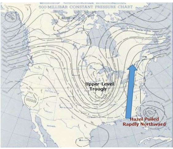
This map indicates upper-level (500 mb) conditions at 7 AM on October 15, 1954. (upper-level trough influences Hurricane Hazel ) Credit- NOAA.
Although Hazel did weaken somewhat, it was moving too rapidly to weaken very much and that is the likely reason why it was able to reach North Carolina as a Category 4 hurricane.
As Hazel galloped northward on October 15th it began to lose most of its tropical characteristics as it interacted with the trough to its west.
So, the extreme wind and rain that occurred over parts of the northeastern U.S. and Canada was really a combination of Hazel’s moisture and energy engulfed in an approaching mid-latitude weather system.
It’s nearly impossible for a Category 4 hurricane make landfall in the U.S. up to North Carolina unless it is racing northward from the tropics.


