It’s that time of year once again when many weather and non-weather sources try to determine what the upcoming winter season will feature in the coming months. What to expect for the winter influences the impact of snowfall on small businesses, school districts, and individuals.
Below is the overall forecast of what to expect in the coming months. For a more detailed analysis which will include impacts from the volcano Hunga Tonga-Hunga, the evolving La Nina state, and other factors for this upcoming winter, please subscribe to Premium Consulting Membership. Of course, you can also learn about what could go wrong with this forecast, a very popular feature for Premium Consulting Members.
THE FORECAST
Based on the data I have available to me, clearly, this winter forecast will be a challenge for verification because of the uncertainty of the impacts of the Hunga Tonga-Hunga on the atmosphere. With that, I see a significant convergence of data to support a weak Polar Vortex that will have the potential to be disrupted several times this winter via enhanced Eliassen-Palm flux transport. These factors are combined with a moderate east-based La Niña with a positive PDO state which has only developed five times since 1900 and has produced near to above-normal snowfall four out of those five times. The most extreme snowfall result from those years was 1995/96 when the Polar Vortex was several disrupted. However, due to influences from Hunga Tonga-Hunga, unlike other years when La Niña was an influence, the subtropical jet stream heading into the winter months is far more active than in any of the years described. Further, while it is true that this is the third year of La Niña, no other third La Niña year on record has had a positive PDO nor volcanic influences, so any correlation simply will not be a viable comparison.
Given these factors, I expect a weather pattern that will be active and feature several phasing solutions between the Plains and the East coast where the Polar and Subtropical jet streams will interact. The potential storm tracks will be dependent on the orientation of the trough around the Aleutian Islands to the Gulf of Alaska which is known as the EPO index.
This winter will likely feature most of the winter weather from mid-December through mid-February. With La Niña expected to weaken, there is some uncertainty as to whether winter weather conditions will continue in late February through mid-March.
STORM TRACKS
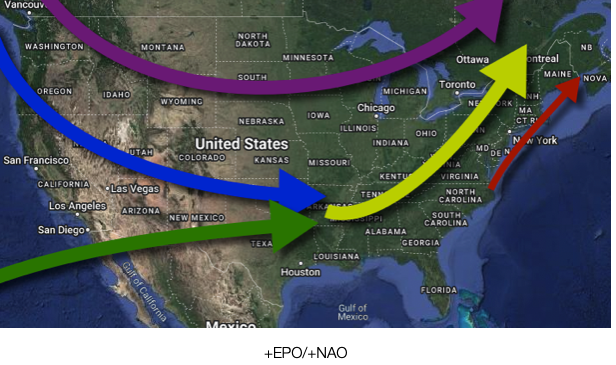
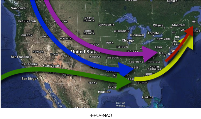
The following discussions will focus on the storm tracks that will be expected on average based on the state of the Eastern Pacific Oscillation (EPO) and North Atlantic Oscillation (NAO). The green arrows are subtropical storm tracks. The blue are polar storm tracks. The purple is arctic storm tracks. The yellow is storm tracks via a phase. The red storm tracks are based on low-pressure system transition from Miller B storms. However, a dominant storm track this winter will include many Miller A storms. In this weather pattern, there is potential for a triple-phase event between the Arctic, Polar, and Subtropical jet streams. With the phasing of shortwaves and a high threat, volatility in the medium-range forecast (days 3 to 7 days out) and long-range (days 7 to 15) will be high and confidence will be low.
While storm track averages can tell us a lot about the potential outcome of the winter, please remember that each individual storm has independent factors that can influence the outcome from the position of the high-pressure system, the nature of available air masses, and even the speed in which the storm moves. As such, this is only an average of what is possible and not a specific forecast.
In this winter weather pattern, the influence of the Arctic jet stream will create a challenging factor to forecast as a sampling of this feature tends to be limited. I would not be surprised to experience one to two arctic air mass invasions for the northern Mid-Atlantic this season, especially in late December and mid-January.
POSITIVE EPO COMBINATIONS
When the trough is in the central and eastern Gulf of Alaska, a trough is more likely around the Rockies and Plains with a phasing potential in the Mississippi River Valley. This weather pattern will force a storm track into the Great Lakes on average. The arctic shortwave typically remains in Canada through a positive EPO weather pattern. If a negative NAO pattern is in place at this time, a significant mixed precipitation event is likely in the Northeast along with a major snowfall in the Tennessee River Valley, Ohio River Valley, and Great Lakes. However, if a positive NAO is in place, a rapid change over to rain would be expected for much of the coastal plain of the Northeast, some wintery mix over the interior and eastern Great Lakes, and snowfall for the central and western Great Lakes.
NEGATIVE EPO COMBINATIONS
When the trough is in the Aleutians to the western Gulf of Alaska, then a mean trough is likely between the Tennessee River Valley and the East coast with a high phasing threat between the central Gulf Coast to the Mid-Atlantic coast. When the NAO is negative, the potential for a significant winter storm will exist from the Tennessee River Valley to the Mid-Atlantic coast and throughout the eastern Great Lakes and New England. When the NAO is positive, the storm track is more likely to be further east and progressive with a non-phasing solution with winter weather threats from the Tennessee River Valley to the southern Appalachians and parts of the Southeastern United States. This storm track is usually a miss for much of the Mid-Atlantic and New England.
NORTHERN MID-ATLANTIC
Overall, I am expecting a winter weather season with near to slightly below normal temperatures for the Northern Mid-Atlantic and near to above normal snowfall. Snowfall expectations are 25”+.
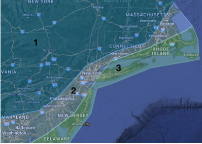
ZONE ONE: Most storm tracks will be to the east of this region with above-normal snowfall expected and below-normal temperatures.
ZONE TWO: Storm tracks will be over or to the east of this region with the potential for significant snow and wintry mix storm threats. Snowfall will be near to above normal and temperatures will be near normal.
ZONE THREE: Storm tracks over or east of this region but still a high threat for change over to rain. Snowfall is near normal and temperatures are near normal.
NATIONAL
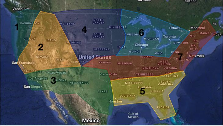
ZONE 1: Impacts from Pacific air masses and possibly a rare arctic air mass. Temperatures will be near normal while precipitation will be near to slightly above normal.
ZONE 2: A ridge will be in place in these regions for most of the winter. As a result, precipitation will be below normal and temperatures will be above normal.
ZONE 3: The unusually active subtropical jet stream will produce a high threat for waves of southern Pacific storms to impact southern California and the Desert Southwestern US. Precipitation will be near to slightly above normal and temperatures near to slightly above normal.
ZONE 4: These locations will have frequent polar air masses and arctic air masses driving into these regions. Precipitation and temperatures will be below normal.
ZONE 5: While the subtropical jet stream will be active, storm tracks are expected to remain north of these locations. Precipitation and temperatures are near normal.
ZONE 6: Lake effect snowfall will be a significant factor in this region however, storm tracks over and east of these locations could push snowfall totals to above-normal levels. Precipitation will be slightly above normal and temperatures below normal.
ZONE 7: Clash of air masses and frequent storms. These locations will feature swings from above to below normal temperatures depending on the state of the EPO and the associated storm tracks. These locations will have the potential to experience significant winter storms this year. Temperatures will be near to slightly below normal and precipitation will be above normal.

