
WINTER FORECAST 2026/27
We broke down the influences on the upcoming winter, with the historic El Nino expected to peak in strength over the next 2 to 4 weeks as the clear driving force. Given the data, this winter will clearly be a second-half winter, with several factors driving periods of high-latitude blocking, shifting tropical convection toward the date line, and a colder cryospheric environment developing after December, especially from mid-January through early March. For detailed analysis on all the factors for this winter, please refer to the Premium Consulting Members’ Winter Forecast.
NOVEMBER SETS UP DECEMBER:
I expect a major stratospheric disruption from late October into early November, producing below-normal temperatures in early November (this idea was written in early October and is now strongly likely in model guidance) and the potential for a coastal storm. I wouldn’t be surprised if we see our first higher-elevation snowfall in early November. However, with a still-strong westerly QBO state, the Polar Vortex will rapidly recover and stay strong from mid-November through at least mid-December, before another strong stretching of the Polar Vortex is possible by late December. Given this lag time, stratospheric disruption would not affect the tropospheric (500 MB) pattern until early to mid-January. This means Pacific air masses would dominate the weather pattern from mid-November through late December. The subtropical jet stream would remain active through this forecast period, with coastal storms producing higher-elevation snowfall, coastal rain, and significant coastal flooding concerns.
THE TURN:
As with most El Ninos, the weather pattern will turn colder and snowier in January and February, whether weak, moderate, or strong. The increasing stretching of the Polar Vortex, the shift of the QBO state toward neutral (below -10 m/s), and the ENSO shift to a stronger, more central state would increase the potential for the Polar and Subtropical jet streams to phase to produce major winter storms. The whole period is not expected to be cold and snowy, but if one or more major winter storms develop this winter, they will be in this period.
STORM TRACKS:
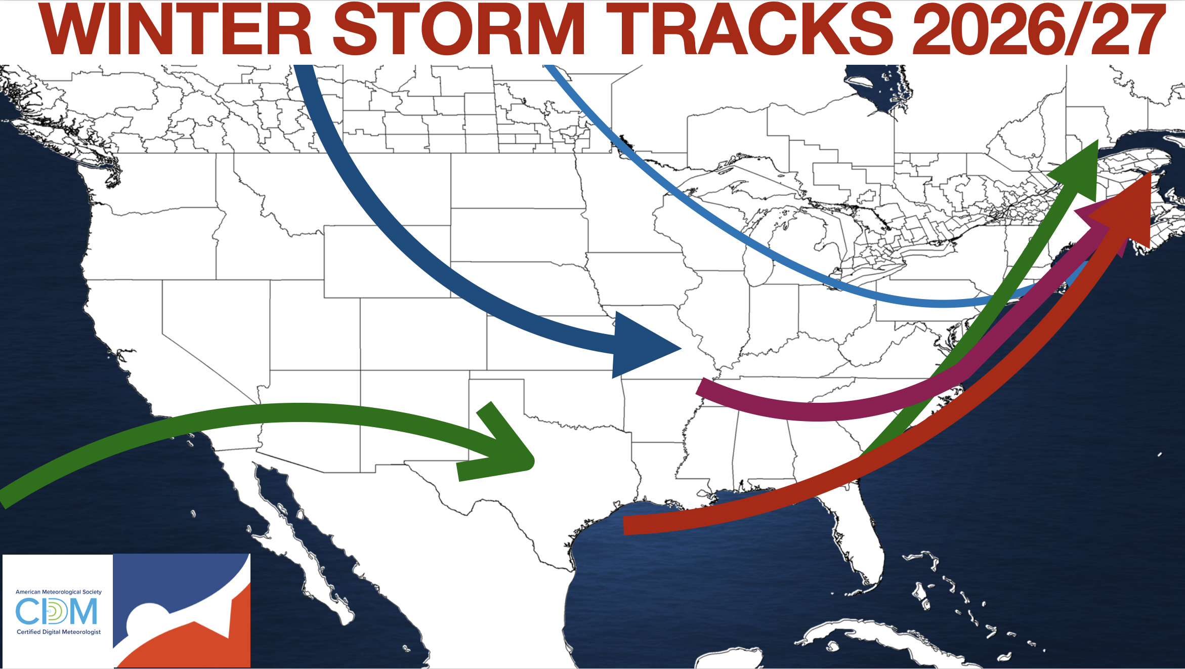
With a very strong El Nino expected to dominate, most storms will originate over the Mississippi River Valley, Tennessee River Valley, and Gulf Coast, with a storm track along the East Coast. The subtropical jet stream will feature several storms moving through southern California into the Desert Southwest and Southern Plains. Meanwhile, the polar jet stream will bring shortwaves and cold fronts south from central Canada. When these shortwaves interact, the red and purple storm tracks are likely, with a high threat for significant winter storms for the Mid-Atlantic and New England. However, if the shortwave interaction is delayed or too fast, the green storm track is more likely, with more snowfall over the interior and rainfall along the coast. In all scenarios, coastal flooding and beach erosion remain threats. Most storm tracks will feature Miller A-type storms, but a few Alberta Clippers and a Miller B-type storm remain possible.
MONTHLY EXPECTATION:
DECEMBER: Overall, a mild month is expected, with limited snowfall potential outside the highest elevations, but still an active weather pattern with above-normal precipitation. Temperatures will be above normal. Snowfall will be below normal below 2,000 feet. Coastal flooding threats will be frequent.
JANUARY: The first half of January is expected to mirror December, but the second half will have a higher potential for winter storms, especially just inland. Precipitation will remain above normal throughout the month. Temperatures will start off near normal but will be near-to-below-normal for the second half of the month. Snowfall will be below normal along the coast and near normal over the higher elevations. However, the second half of January will feature an increasing threat for a region-wide winter storm. Coastal flooding threats will be frequent.
FEBRUARY: February will be the coldest month of the winter as El Nino weakens. Temperatures will be near-to-below normal. Precipitation will remain above normal. This month will feature the best potential for a region-wide winter storm. Snowfall this month will be near-to-above-normal.
ZONES:
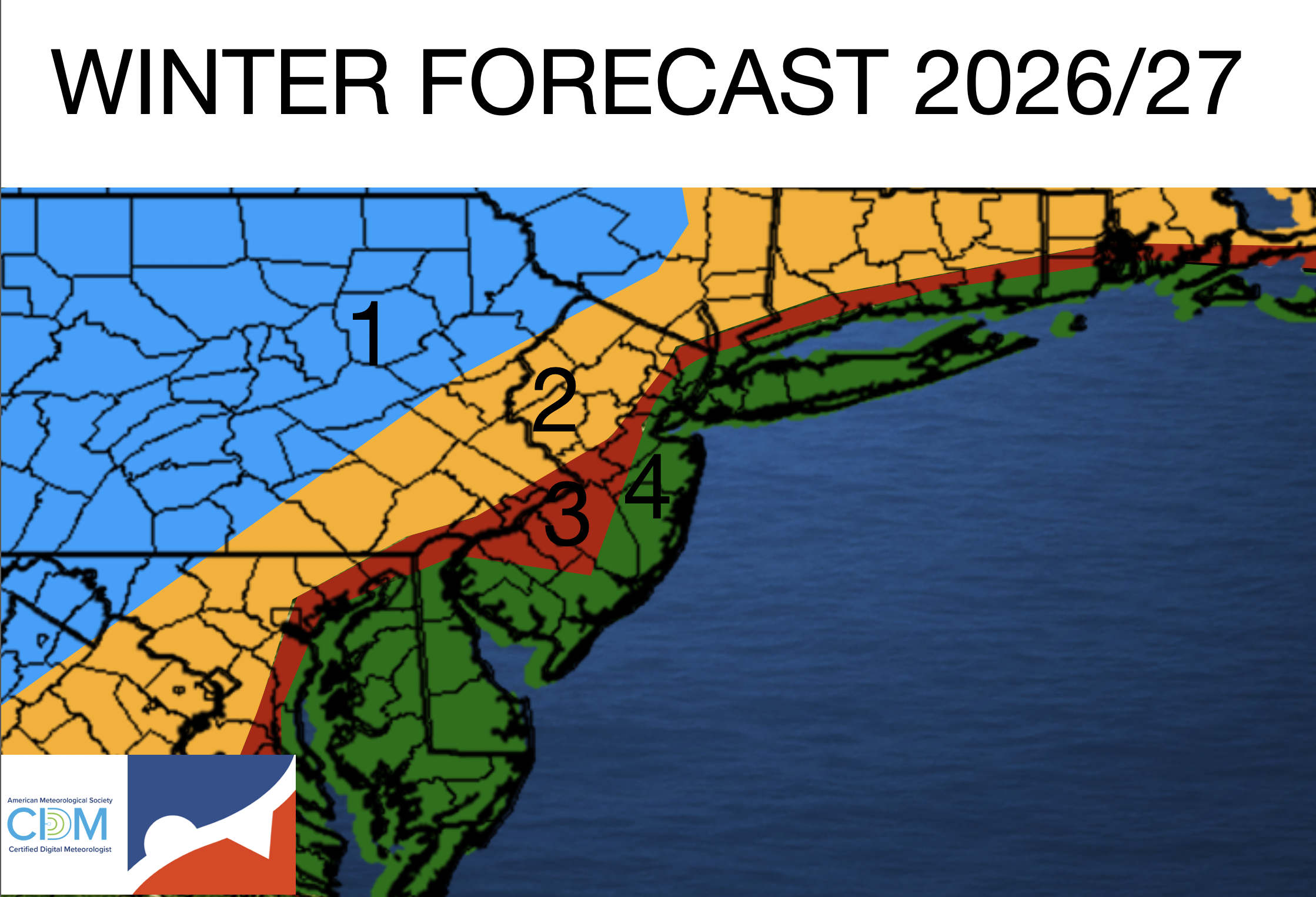
ZONE 1: This zone will see the most frequent all-snow events with near-to-above-normal snowfall throughout the winter, while most of the rest of the region will see rain. If you want snow all winter, go here!
Snowfall Range: 50″-80″
ZONE 2: Many storms will feature a wintry mix that eventually turns to rain. Snowfall will be replaced with more sleet and rain. Often, rain will wash away a few inches of snow by the storm’s midpoint. December will feature below-normal snowfall. January will be near normal. February will be above-normal snowfall.
Snowfall Range: 20″-50″ with significant ice impacts possible. Most of the snow may fall in one storm.
ZONE 3: This zone will see a mix of icy rain events, but not much snow. Snowfall will be below normal, but precipitation will be above normal, meaning plenty of rapid snow, then freezing rain, and then rain. December will feature below-normal snowfall. January will be near- to below-normal. February will be near- to above-normal snowfall.
Snowfall Range: 10″-40″ with significant ice impacts possible. Most of the snow may fall in one storm.
ZONE 4: Most storms in this zone will bring rain, with perhaps a brief period of snow at the very start and end of coastal storms. Coastal flooding and beach erosion will be a major concern with multiple Miller A-type winter storms. Snowfall is expected to be below normal. December will feature below-normal snowfall. January will be near normal. February will be near-normal snowfall.
Snowfall Range: 10″-40″. Most of the snow may fall in one storm.
WILD CARD ALERT! While most of the winter will feature a progressive, mild weather pattern, there is an outlier threat that is featured in many very strong El Nino events like this one: one or two storms coming out of the Gulf Coast and tracking the coastal waters of the region that can produce a season’s worth of snow in one shot. While it is impossible to forecast when and if such a storm will happen, it is important to acknowledge that threat, which can turn a winter snowfall result like 1998/99 into 2015/16 with just one storm.
Examples include:
February 1983: The Megalopolitan Blizzard
January 2016: The January 2016 Nor’easter
WHAT CAN GO WRONG!
Seasonal forecasting is always difficult to verify because of so many unexpected wild cards and developments, from ionospheric interaction to volcanoes. So, let’s discuss which factors can throw this forecast in the trash and what results they could produce. Blue are cold results, and red are warm results.
- Major disruption of the Stratospheric Polar Vortex in late November that lingers through December. In this situation, the Polar Vortex splits completely and influences the troposphere (500 MB), driving polar air masses southward to interact with a very active subtropical jet stream. The result would be a very active winter from December through March, lots of coffee purchases, and little sleep for me. Snowfall would be above-normal throughout the region, with the most significant impacts in zones 2, 3, and 4. (LOW POTENTIAL)
- After the disruption in late October and early November, the Polar Vortex becomes very strong, and the stratosphere shifts to cold anomalies, keeping cold air trapped in Canada through January and limiting any cold to February. Basically a repeat of 1997/98. (MODERATE POTENTIAL)
- El Nino weakens but remains east-based, limiting the potential for winter storms from mid-January through February and keeping snowfall below normal across the region. (HIGH POTENTIAL)
- A perfect phase of the Arctic, Polar, and Subtropical jet streams in January produces major-to-historic winter storms with snowfall amounts in the feet, not inches, range. This storm creates a feedback loop with high-latitude blocking (negative NAO) that forces a weather pattern that produces another 2 or 3 moderate-to-major winter storms through February. This would produce above-normal snowfall across all zones. (HIGH POTENTIAL)
- Godzilla returns, fights aliens, and creates a long winter that lasts for several decades. Potential is very low, but you never know. (VERY LOW POTENTIAL)


