
Summer can feature a variety of notable weather events. One of them is a derecho which can produce a large area of destruction. A derecho is a widespread, long-lived windstorm associated with a band of rapidly moving showers and thunderstorms. A storm is classified as a derecho if wind the damage extends more than 240 miles and has wind gusts of at least 58 mph or greater most of the length of the storm’s path.
Just two years ago, a long-lived derecho event produced widespread damage across parts of the Midwest, including the Chicago area. It also spawned a large number of tornadoes.
The Event – Beginning on July 13-14
This weather event actually began in Canada on July 13th as a complex of thunderstorms moves southward into the U.S. and it eventually dissipated in the northern Plains. To the east, a separate weather system , early on July 14th, produced heavy rain and severe flooding conditions across northern Illinois, Over six inches of train fell at Rockford. There were a few weak tornadoes spawned by this system and two of them touched down in the Chicago area but we will mainly focus on the severe derecho that began on July 15th.

A photo from Chicago, Illinois, showing an uprooted tree from a minor tornado on July 15, 2002. Photo Credit- NWS.
July 15th
The most impactful part of this event began on July 15th and it continued into July 16th. A complex of thunderstorms erupted in eastern Iowa with heavy rain and powerful winds. Wind gusts exceeded hurricane force as the system pushed out of Iowa to Illinois . The fierce gusts peaked at 105 mph at Camp Grove, Illinois in the north central part of the state.
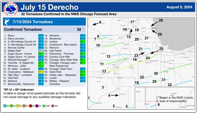
The storms were fed by extreme instability in the atmosphere. The Storm Prediction Center issued a large area of a moderate risk or an enhanced risk of severe weather with numerous tornadoes likely . The derecho ignited a significant tornado outbreak with tornadoes reported i Des Moines and Davenport in Iowa and Aurora, Naperville and Joliet, Illinois. A tornado also produced minor damage in downtown Chicago. There was an EF2 tornado in Jo Daviess and Stephenson counties and another EF2 tornado in Will and southern Cook Counties .
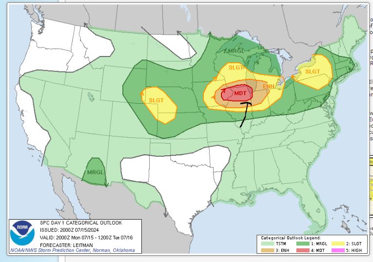
Storm Prediction Center severe weather outlook posted on July 15, 2004 (note the moderate risk from the Mississippi River area to the Great Lakes). Map Credit-SPC.
Forecasting and warning operations of NWS Chicago were moved to the NWS office in Gaylord, Michigan.
Overall, a record of 32 tornadoes were confirmed in the county warning area of National Weather Service Chicago, a record previously held by the July 2014 derecho and the tornado outbreak of March 31 to April 1, 2023.
Meanwhile, there was severe and triggered severe flooding, including a partial dam failure in Washington County, Illinois.
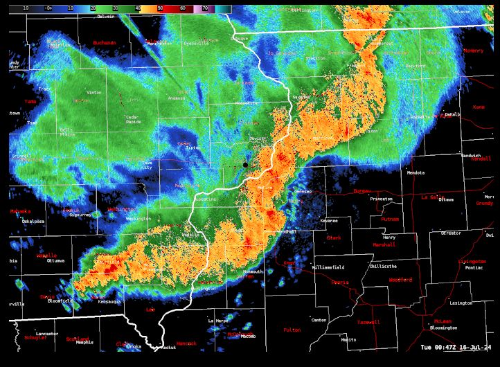
NWS Quad Cities radar shows a derecho moving east of Iowa into Illinois on July 15, 2024. Image Credit-NWS.
July 16th
The Storm Prediction Center issued an enhanced risk convective outlook over areas of New York and Vermont as the remnants of the Midwest derecho (now a weakening mesoscale convective system) would interact with the region’s extreme instability which would generally favor a severe wind event with lesser tornadic potential. There were 10 tornadoes, however, including a high level EF-2 tornado (winds over 135 mph) in my hometown of Rome, NY. causing major damage to two churches, ripping the roofs off of several buildings, and uprooting hundreds of trees. Over 400 structures were damaged in the city.

NWS photo showing significant (high Ef-2) tornado damage in Rome, New York, on July 16, 2024.
All in all, five people lost their lives in this event. There was widespread property damage and power outages. The estimated damage from the derecho itself was around 1 billon dollars !


