
July has been notorious for major flooding events. Sometimes the floods are triggered by tropical systems from the Atlantic or Gulf moving slowly inland into the U.S. and sometimes flooding can occur with a slow-moving mid-latitude weather systems with at atmosphere filled with ample tropical moisture. We have seen a good share of flooding in recent years in the summer months with atmospheric moisture sending dew pointe to extraordinary high levels s ocean temperatures rise.
This time we will go back 84 years to an overwhelming flood event in Pennsylvania that set some all-time records with nearly 31 inches of rain at one location!
In the area around Smethport and Port Allegany, Pennsylvania, the skies darkened on the morning of July 18, 1942. Rain had already fallen the night before but the next few hours would be “hell on earth” as described by one area resident. The rain began to fall, it became relentless and unforgiving. Lightning darted across the sky among the clouds. In less than 5 hours, a world record rainfall had inundated the area, lives were lost and many became homeless.
The Storm
Around 8:30 p.m. on Friday, July 17, 1942 rain began to come down furiously near Cohocton New York. Heavy rain and thunderstorms continued and thunderstorms moved into Pennsylvania.
The rain became extremely heavy in the area around Smethport and Port Allegany, on Saturday, July 18th. In much of the area, the most intense rain fell in a 5-hour period. Residents indicated that the electrical storm was the worst they had ever witnessed. Lightning was constant across the sky, but much more from cloud to cloud than from cloud to ground. As floodwaters continued to rise, and the relentless rain continues, many thought that they would drown.
Local residents recalled that the rain wasn’t just falling in drops, but rather like streams. Here are some accounts from one area in Pennsylvania.
In the Austin, PA region, many people said the rain did not come down in drops, and they had the visual impression, at least, that the rain came down in streams which they likened to strings and ropes… there were people who had not been able to reach shelter and were afraid they would drown during the downpour through lack of oxygen. One man expressed the effect by saying it was just like breaking water after a long dive, lungs bursting, with water pouring down over his head.
The dam at the Williamson Pulp and Paper Company at Austin was breached which hastened the ooding of the town as you can see in the photo below (from a USGS report- see link below).
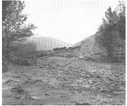
There were reports of massive quantities of gravel and rock being washed down small gullies and deposited as alluvial fans at the mouths and even reports of bedrock being ripped out and carried downstream as the relentless rain continued.
There were numerous reports of debris flows or “blowouts”, where all overburden above the rock became fluid and owed down steep hillsides.
One debris flow swept from the top of a hill to its bottom in Kettle Creek, a distance of more than a mile. The flow was narrow at the top and roughly a quarter-mile wide at the bottom. Some slides moved for hundreds of feet with trees upright, and some of the trees were later found to continue growing in the new location “as though nothing had happened.
In Emporium, Pennsylvania, an incredible amount of rain fell in a short period of time. The estimated rainfall rate was over 10 inches per hour! There was massive flooding over a short period of time. Here are a couple of photos taken in a 1-hour period. The dikes at Emporium were breached and most businesses suffered extreme damage. Here are photos from Emporium taken 1 hour apart.
(USGS/Ginny’s Geneology Page).
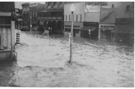
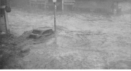
There were many accounts of an “almost instantaneous rise” in the water from 5 to 8 or 10 feet. Buildings in Austin were being knocked off their foundations and the water was 4 to 5 feet deep on the main street.
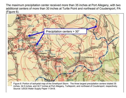
It appears that the heaviest rain fell between Smethport and Port Allegany, Pennsylvania. Some locations received a whopping 34.50 inches of rain from the event. A rainfall total of 30.7 inches of rain in a 4 1/2 hour period set a world record around Smethport where extremeflood damage was reported.
Storm Impacts
Here is an account of the storm from a USGS publication :
On July 18, 1942, north-central Pennsylvania and adjacent areas in New York was visited by destructive floods of unprecedented magnitude. The principal areas affected were in Elk, Cameron, McKean,
and Potter Counties in Pennsylvania, and Cattaraugus, Allegany, and Stueben Counties in New York. (See g. 26.)
Rainfalls of more than 30 inches were reported in several localities, and on about 200 square miles the rainfall was as much as 20 inches. The rainfall was greater than 10 inches on more than 2,000 square miles.
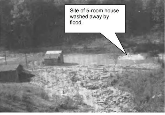
A photo of incredible flooding in north central Pennsylvania that was away homes. Phot0-Public Domain.
The resulting foods produced the highest crest stages ever recorded on First Fork and Driftwood Branch of Sinnemahoning Creek and on upper Allegheny and Clarion Rivers. Flood discharges on small drainage areas less than 100 square miles were as great in relation to drainage area as any ever recorded on streams in Pennsylvania and adjacent areas in New York.
Practically all the towns along the streams were inundated to a damaging extent. The dikes at Emporium, Pa., were overtopped and about 60 percent of the town was flooded; the water was 5 feet deep in the middle of Broad Street Square. At Austin, Pa., events were reminiscent of the historic flood disaster of September 30, 1911, when the dam broke and 80 people were killed.
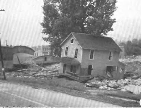
The photo shows houses knocked off of their foundations due to floodwaters at Austin, Pennsylvania on July 18, 1942. (USGS).
The dam of the Williamson Pulp & Paper Co.’s reservoir with a capacity 65,000,000 gallons at spillway crest was breached, pouring floodwaters upon the town of Austin; buildings were knocked off their foundations and water was 4 to 5 feet deep on the main street. Many residents of the area were rendered homeless by the event.
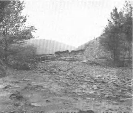
Photo showing floodwaters after a dam break at Austin, Pennsylvania on July 18, 1942. Photo Credit-USGS.
Port Allegany probably suffered the greatest damage per capita of any town in the area. Virtually every business building was flooded 3 to 20 feet.
More than 150 people attending a conference in the Free Methodist Church were rescued from treetops, roofs, and floating wreckage.
The church was washed against a nearby silk mill; it caught fire and both buildings as well as others adjacent were destroyed.

Surface weather map for July 17, 1942, shows a stationary frontal boundary over the eastern Great Lakes. Map Credit- NOAA Central Library. Impact area (purple)
Above Johnsonburg, Pa., a dam broke, and a wall of water 8 feet high was reported as having swept through the town. Eighteen families had to be rescued with makeshift rafts, and many houses were moved off their foundations and pushed together All these communities supported industries that suffered heavily, at a time when capacity production was needed for the war effort.
Public utilities and transportation systems were badly damaged.
Water, gas, and electric services were disrupted in many communities. Railroads, highways, and bridges were washed out.
A passenger train was marooned by the collapse of a bridge near Ridgway. It was estimated that 75 miles of Pennsylvania Railroad track were damaged.
The Coudersport and Port Allegany Railroad between Roulette and Port Allegany and the Baltimore & Ohio Railroad between Sinnemahoning and Austin were so badly damaged that they were abandoned. Overall the 27 miles of this stretch of the Baltimore & Ohio Railroad suffered extreme damage.
The situation could have been much worse. Three separate drainage basins were involved with the storm the Susquehanna, owing into the Chesapeake Bay, the Allegheny, the headwaters of the Ohio River; and the Genesee, tributary to the Saint Lawrence River. The distribution of rainfall over three basins explains the lesser severity of ooding on the main stems of these rivers, compared to the headwater streams and runs of each basin.
All told, 15 people lost their lives in the storm and damage estimates were around 10 million dollars (150,000,000) today.
Meteorological Assessment
The U.S.Weather Bureau and the United States Geological Survey assessed the storm. Here is a rainfall map of the impacted area showing more than 35 inches at Port Allegany, Pennsylvania.
In 2009, a more detailed assessment was produced in 2009 by Ed Tomlinson, Ph.D. and Bill Kappell (Applied Weather Associates) and Dwight D. Hoare, P.E. St. Marys, PA (Water Authority. Here are their findings – applied weather associates.com
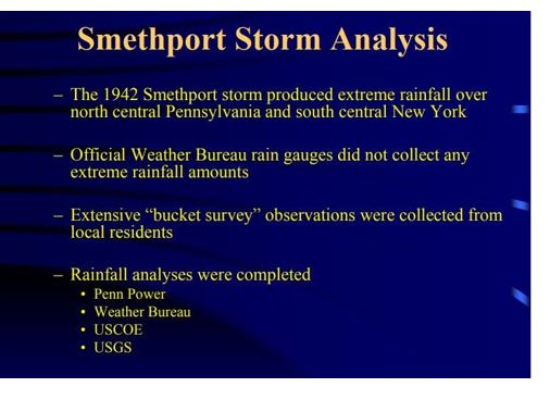

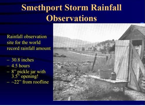
This assessment was presented at the Northeast ASDSO Conference at State College, Pennsylvania (June 14-16) 2009.
Here is the surface weather map for Friday, July 17, 1942. There was a stationary frontal boundary that was draped over the Great Lakes and it extended into New York. With a static boundary like that, the upper-level winds were probably light so any storms would be sow-moving. There was ample moisture (high dewpoints).
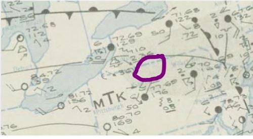
Surface weather map for July 17, 1942, shows a stationary frontal boundary over the eastern Great Lakes. Map Credit- NOAA Central Library. Impact area (purple)
The frontal boundary over the Great Lakes could have been a triggering mechanism for the “Mesoscale Convective Complex” that is mentioned in the report above. There was obviously clustering and “training” of thunderstorm cells. The hilly terrain acted as a lifting mechanism which enhanced precipitation.
Fifteen people died in the event and estimated damage was 10 million dollars (206 million 2026 dollars) .
Hopefully, this area won’t see anything like this again!


