


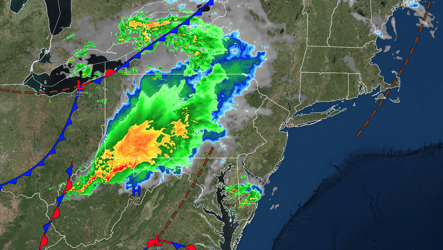
Showers and thunderstorms will be a threat this afternoon and evening. An unsettled weather pattern will take hold thereafter.
TODAY
An area of low pressure will produce periods of showers and thunderstorms this afternoon. A few thunderstorms may reach severe levels in southern New Jersey with heavy downpours, frequent lightning, hail, and wind gusts over 60 mph. Winds will be from the southwest at 5 to 15 mph. Temperatures will rise into the upper 60s to mid-70s over the interior, upper 70s to lower 80s in the Delaware River Valley, and mid to upper 70s along the coast for highs.
TONIGHT
An area of low pressure will pass through the region with variable clouds and scattered showers and thunderstorms. Winds will back to the northeast at 5 to 15 mph. Temperatures will fall into the mid to upper 50s over the interior and upper 50s to lower 60s along the coast for lows.
TOMORROW
An area of low pressure will exit the region with variable clouds and scattered showers. Winds will back from the northwest at 5 to 15 mph. Temperatures will rise into the lower to mid-70s over the interior, upper 70s to lower 80s in the Delaware River Valley, and lower to mid-70s along the coast for highs.
TOMORROW NIGHT
A series of troughs will pass through the region with scattered clouds and isolated showers. Winds will be from the northwest at 5 to 15 mph. Temperatures will fall from the mid to upper 50s over the interior and upper 50s to lower 60s along the coast for lows.
SUNDAY
A trough will pass through the region with scattered clouds and isolated showers. Winds will be from the northwest at 5 to 15 mph. Temperatures will rise into the mid to upper 70s over the interior, lower to mid-80s in the Delaware River Valley, and upper 70s to lower 80s along the coast for highs.
MONDAY
An area of low pressure will linger to the south of the region with scattered clouds and isolated showers. Winds will veer to the east at 5 to 15 mph. Temperatures will range from the lower to mid-50s over the interior and upper 50s to lower 60s along the coast for lows and upper 70s to lower 80s over the interior, mid to upper 80s in the Delaware River Valley, and upper 70s to lower 80s along the coast for highs.
TUESDAY
An area of low pressure will linger to the south of the region with scattered clouds and isolated showers. Winds will veer to the east at 5 to 15 mph. Temperatures will range from the lower to mid-50s over the interior and upper 50s to lower 60s along the coast for lows and upper 70s to lower 80s over the interior, mid to upper 80s in the Delaware River Valley, and upper 70s to lower 80s along the coast for highs.
WEDNESDAY
An area of low pressure will linger to the south of the region with scattered clouds and isolated showers. Winds will veer to the east at 5 to 15 mph. Temperatures will range from the lower to mid-50s over the interior and upper 50s to lower 60s along the coast for lows and upper 70s to lower 80s over the interior, mid to upper 80s in the Delaware River Valley, and upper 70s to lower 80s along the coast for highs.
THURSDAY
An area of low pressure will linger to the south of the region with scattered clouds and isolated showers. Winds will veer to the east at 5 to 15 mph. Temperatures will range from the lower to mid-50s over the interior and upper 50s to lower 60s along the coast for lows and upper 70s to lower 80s over the interior, mid to upper 80s in the Delaware River Valley, and upper 70s to lower 80s along the coast for highs.
FRIDAY
An area of low pressure will linger to the south of the region with scattered clouds and isolated showers. Winds will veer to the east at 5 to 15 mph. Temperatures will range from the lower to mid-50s over the interior and upper 50s to lower 60s along the coast for lows and upper 70s to lower 80s over the interior, mid to upper 80s in the Delaware River Valley, and upper 70s to lower 80s along the coast for highs.


