

Residents of Indianapolis, Indiana, wrapped up their school and work weeks. On Friday, October 13th, 1989 they were basking in warm sunshine with the high temperature around 80 degrees. The weekend was also perfect for outdoor activities and they took advantage of temperatures in the 70s to near 80 while wearing only shorts and shirt sleeves. Monday was also quite warm and there were severe thunderstorms in the area. The temperature tumbled on Tuesday behind a cold front. On Wednesday, the temperature dipped to the mid 30s and a light snow began to fall. By the end of Thursday, Indianapolis and the surrounding region, would be shocked by a record snowfall for the month of October.
Many of us are well aware that weather conditions can change rapidly in the fall and spring. Snow can fall in the lower elevations, even in October and April. For parts of northern Illinois, southern Michigan, much of Indiana and western Ohio weather conditions came together just right for the weather to change rapidly and for significant snow to fall.
Record Snowfall
As the snow began to fall on Wednesday, October 18, 1989 across parts of the Midwest, especially in Indiana, the temperature was a far cry from what it had been over much of the past few days.
Only 0.2 inches of snow fell at Indianapolis on October 18th but that set the record for their earliest snowfall on record. The snow became much heavier on Thursday, October 19th and it lasted into October 20th. All told, 9.3 inches of snow fell at Indianapolis which is their greatest October snow event.
With temperatures hovering around the freezing mark, the snow was especially heavy and wet. Trees and power lines were down all over central and northern Indiana. Thousands of customers were without power.
The Marion County Police Department reported that there were over 100 accidents on the area roadways on Thursday the 19th.
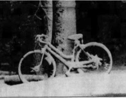 This photo shows a bicycle encased in snow in Indianapolis, Indiana, on October 19, 1989. Photo Credit- newspaper archives.com/indystar.
The high temperature at Indianapolis on October 19th set a record for the lowest high temperature for that date with 35 degrees.
Indianapolis wasn’t the only area that picked up significant snowfall. Kokomo, Indiana, picked up 10.5 inches of snow from the storm. Nearly 4 inches fell around Chicago, Illinois, and up to 6 inches blanketed parts of southwest Michigan. Cincinnati, Ohio, picked up 5 inches and that was a record for their earliest measurable snowfall. Dayton, Ohio, also recorded their earliest measurable snow.
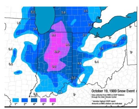
Map indicates total snowfall associated with the the snow event from October 18-20, 1989. Map Credit- blogspot.com-NWS.
Although the heavy wet snow was not good for the roadways and power lines conditions were ideal for the youngsters to engage in snowball fights. The heavy snow also weighed down on trees and branches fell on power lines which created scattered outages.
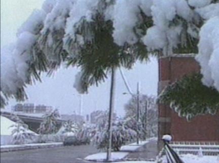
The weight of heavy snow on trees in shown in this photo from Indianapolis, Indiana, on October 20,1989. Photo Credit – WTTV.
Meteorological Conditions
Here is a summary of the snow event from the National Climatic Data Center.
“An intense upper-level low pressure system was anchored over the Missouri bootheel which allowed warmer, southerly winds to override colder surface air over Indiana. Snowfall began to accumulate on grassy and exposed areas as the air temperature hovered near freezing. By 0700 EST, accumulations of five to six inches were recorded from across central Indiana, and elevated roadways and bridges were becoming ice covered. The ice conditions became only wet by late morning as the temperatures rose to the middle thirties and road crews had spread salt on affected areas. Another problem was the wet, heavy snow was the large accumulation on power lines, and especially on trees, since many trees still had a substantial number of leaves. Scattered power outages were reported from across central Indiana…”
“The axis of maximum snowfall was from South Bend to Indianapolis to Bedford (Lawrence
County). The maximum snowfall was 10.5 inches at Kokomo in Howard County.”
NCDC conducted a study of the storm.

The map shows upper-level atmospheric features on October 19, 1989 including closed low pressure over the lower Midwest, Map Credit-NOAA.
Basically, an area of low pressure aloft became cut off from the main upper-level flow over southeast Missouri. The upper low was able to transport cold air from aloft to the surface.
At the surface, low pressure moved slowly from the southern Plains to the west side of the Appalachians. Moisture from the Gulf of Mexico was able to override the cold air aloft and snow developed. The upper low provided the atmospheric lift necessary to increase the rate of the snowfall. The upper low finally began to move northeastward by Friday and the snow tapered off to occasional snow showers.
Fortunately, temperatures became warmer by the weekend and the snow disappeared in a hurry.
October Caveat
In 1989, the storm was a bit of a surprise but events like that are much better forecasted these days. Just remember that in months like October, weather conditions can change in a hurry. If you plan to go hiking or camping, especially in mountains or out of the way areas, check ahead to see what weather conditions can be expected during your activity.


